Provinces/States of Nepal
- By Malika Karki
- August 20, 2022
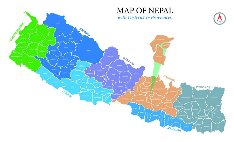
The federal democratic republic of Nepal has 7 states/provinces and 753 local bodies. According to article number 56 of the constitution of Nepal, the Government of Nepal consists of three levels: the federation, the state & local levels. Nepal is divided into 77 districts and 6,743 wards. The local level consists of 6 metropolises, 11 sub-metropolises, 276 municipalities, and 460 rural municipalities.
Table of Contents
ToggleName of 7 provinces are:-
Province No. 1
In the east, it is bordered by West Bengal and Sikkim, while in the south, it is bordered by Bihar. The Tibet Autonomous Region of China lies to the North, and Province No. 2 lies to the west. Taplejung, Panchthar, Ilam, Sankhuwasabha, Tehrathum, Dhankuta, Bhojpur, Khotang, Solukhumbu, Okhaldhunga, Udaipur, Jhapa, Morang, and Sunsari are 14 districts in Province No. 1. This province has a total area of 25,905 sq Km. It occupies 17.60% of the total land in Nepal. The largest district of this province is TapleJung (3,646 sq km), and the small district is Tehrathum (679 sq km). Currently, the capital of this region is Biratnagar (Morang).
According to the Central Statistics Department, there are 9,92,445 families in this province. The total population is 45,34,943 (21,66,536 males and 23,68,407 females).This state is ethnically and linguistically diverse and home to Brahmin, Chhetri, Rai, Limbu, Tharu, Lepcha, Tamang, Gurung, Meche, Koche, Yadav, Rajbanshi, and many others. Nepali, Maithili, Kirati, Tamang, Limbu, Gurung, Lepcha, Magar, and Tharu languages are mainly spoken in this state.
The world’s highest mountain Sagarmatha (Mount Everest), lies in this state. Kanchenjunga, Cho Oyu, Makalu, and Lotse are famous mountains in this region. Famous places like Ilam, Namche Bazaar, Everest base camp, etc., are this province’s main tourist attractions. The famous Pathivara temple is also located in the Taplangjung district of this state. This state of Nepal is rich in water resources. The state is rich in water resources. Continuously flowing rivers like Mechi, Arun, Tamor, and Dudhkoshi are famous rivers of this state.
Districts and their headquarter in Province no. 1
Province No. 2(Madhesh Pradesh)
This province is surrounded by Province No. 1 in the east and North. To the south is India, and Bagmati Province in the west. There are eight districts, namely Dhanusha, Mahottari, Sarlahi, Rautahat, Bara, and Parsa, with 136 local levels in this province.
The total area of this province is 9,661 square kilometers. (covers 6.575% of the total area of Nepal). The largest district of this state is Saptari (1,363 sq km), and the smaller district is Mahottari (1,002 sq km). The Janakpur (Dhanusha) is the capital of this province.
The total population of this state is 54,04,145, of which the number of males is 27,17,938, and the number of women is 26,86,207 (source: Central Statistics Department). The state is ethnically and linguistically diverse. This province is mainly home to Yadav, Gupta, Das, Tharu, Rajbanshi, Muslims, and other castes. The Maithili, Rajbanshi, Urdu, Hindi, Tharu, and Nepali languages are spoken mostly.
The Janaki Temple (birthplace of Sita) is a religious and tourist place in this state. The biggest river in Nepal, the Saptakoshi river, flows through this state.
Total Districts and headquarters of madhesh Pradesh( province no 2)
Province No. 3 ( Bagmati Pradesh )
Bagmati province is bordered by Region 2 to the east, Gandaki Province to the west, and China to the North and south. Dolakha, Ramechhap, Sindhuli, Kavrepalanchok, Sindhupalchok, Rasuwa, Nuwakot, Dhading, Chitwan, and Makwanpur, are 13 districts, including Bhaktapur, Lalitpur, and Kathmandu(capital of Nepal). The total area of this province is 20,300 square kilometers. ( covers 13.795% of the total area of Nepal).
The largest district of this region is Sindhupalchok (2,542 sq km), and the smaller district is Bhaktapur(119 sq km). The capital of this province is the town (Makwanpur). According to the Central Statistics Department, there are 12,70,797 families in this province. The total population is 55,29,452 (27,47,633 males and 27,81,819 females).
There is ethnic and linguistic diversity in this province. Mainly home to Tamang, Brahmin, Kshetri, Newar, etc. Nepali, Newari, and Tamang languages are mainly spoken in this Bagmati state.
The Bagmati province is rich in art and culture. The famous temples listed in UNESCO world heritage sites like Pashupatinath, Patan, Swyambhunath, Bouddhanath, and Changunarayan are in Bagmati province. Chitwan National Park, Langtang National Park, and Shivapuri Nagarjun National Park are famous tourists area in this state. Chandragiri hills and Annapurna base are famous for trekking and hiking.
Total Districts and headquarters of Bagmati Pradesh( province no 3 )
Province No. 4 ( Gandaki Pradesh )
The Bagmati region surrounds the Gandaki region on the west, the Karnali region, and Lumbini on the west. China also borders the state to the North and India’s Bihar to the south. In Gandaki province, Gorkha, Lamjung, Tanahun, Kaski, Manang, Mustang, Parbat, Syangja, Myagdi, Baglung and Nawalparasi (Bardghat) are 11 districts.
The total area of this province is 21,733 square kilometers (which covers 14.615 of the total area of Nepal). The largest district of this province is Gorkha (3,610sq km.). The smaller district is Parbat(494 sq km). The capital of this province is Pokhara (Kaski).
According to the Central Statistics Department, there are 5,78,219 families in this province. The total population is 24,03,757 (10,90,808 males and 13,12,949 females). In this ethnically and linguistically diverse province, Brahmins, Kshetri, Gurung, Magar, and other ethnic groups live there. The Nepali, Gurung, and Magar language is mainly spoken in Gandaki province.
Gandaki province consists of one of the most beautiful cities in Nepal. Pokhara is famous for Phewa Lake, Devi’s Fall, Mahendra Cave, International Mountain Museum, and Annapurna Mountain. Tilicho lake and Upper mustang are famous for trekking and hiking.
Total Districts and headquarters of Gandaki Pradesh( province no 4)
Province No. 5( Lumbini Pradesh )
Province no 5 Lumbini Pradesh is surrounded by Gandaki Province to the east, Karnali Province to the west, and Sudurpaschim to the east. The state includes Gandaki Province and Karnali Province in the North and India in the south.
Nawalparasi (Bardghat Susta West), Rupandehi, Kapilvastu, Palpa, Arghakhanchi, Gulmi, Rukum (eastern part), and Palpa, Pyuthan, Dang, Banke, and Bardia are 12 districts of this state. The total area of this province is 22,288 square kilometers (which covers 15.145% of the total land of Nepal). Dang is the largest district in this province.
(2,955 sq km.) and the small district Nawalpara (west) of 634.88 sq km. The capital of this province is Bhaluwang (Dang).
According to the Central Statistics Department, there are 8,85,203 families in this province,
The total population is 44,99,272 (21,40,316 males and 23,58,956 females).
In this ethnically and linguistically diverse province, mainly Brahmins,
Chhetri, Magar, Tharu, Tamang, Nepali, Muslim, and other ethnic groups live here.
Nepali, Tharu, Bhojpuri, Urdu, and Magar languages are mainly spoken in Lumbini State.
The Lumbini province is the birthplace of Gautam Buddha. Dang Vally (the largest valley in Asia) lies in this region. Bardiya National Park, Banke National Park, and Blackbuck Conservation area are some famous parks for conserving endangered animals. It is also one of the famous tourist areas in this province.
Total Districts and headquarters of Lumbini Pradesh( province no 5 )
Province No. 6 (Karnali Pradesh )
On the other hand, Kanarli Pradresh is covered with Gandaki Pradresh and Lumbini. To the west is Sadurpachim pardesh.
China to the North and Lumbini to the south.
In Karnali Pradesh Rukum (West), Salyan, Dolpa, Jumla, Mugu, Humla, Kalikot, are 10 districts including Jajarkot, Dailekh, and Sukhert.
The total area of this province is 27,984 km. (covers 19.015% of the total land of Nepal). The largest district is Dolpa (7,889 km), and the smallest District is Rukmu West(1,213.49 km). The capital of this state is Brindranagar in Surkhet.
According to the Central Statistics Department, there are 2,98,359 families in this province. The total population is 15,70,418 (male 7,67,923 and female 8,02,495). This state is ethnically and linguistically diverse. Mainly Brahmins, Thakuri, Chhetri, Sherpa, Gurung, Magar, and other castes are living. Nepali, Gurung, and Magar languages are mainly spoken.
Rara lake, Shey Phoksundo lake, Syarpu lake, Jagadulla lake, and Bulbule lake are famous lakes in this region. Rara National Park and Shey Phoksundo National Park are this region’s famous national parks and tourist areas.
Total Districts and headquarters of Karnali Pradesh( province no 6 )
Province No. 7 ( Sudurpaschim Pradesh )
Karnali Province and Lumbini Province east of Sudurpaschim Province, India, on the west and south. To the North lies Karnali Province and China. In the Far West Province, Bajura, Bhavfang, Doti, Achham, Darchula, Baitadi, Dadeldhura,
There are 9 districts, including Kanchanpur and Kailali. The total area of this province is 19,539 km. (covers 13.285% of the total land in Nepal). The larger district is Bavfung (3,422 sq. km), and the smaller district is Baitadi (1,519 sq. km). The capital of this province is Godavari (Kailali).
The number of households in this state is 4,69,971. The total population is 25,52,517 (males 12,52,517 and females 13,34,630 people). Brahmins, Kshetris, Thakurs, and Tharu castes live there. The Doteli, Khas, and Tharu languages are mainly spoken.
Khaptad National Park, Shuklaphata National Park, Naini Lake, Jhilamila Lake, Ghodaghodi Lake, Dodhara Chadhani bridge, Karnali bridge, Tikapur Park, Lipulekh, Limpiyadhura, Kalapani are the famous place of this region.